Katahdin

Katahdin
Aug 17 2010 - End of Part 1

Saturday, July 31, 2010

31 July - Safford Notch Campsite

Mostly sunny high in low to mid 60s.  Felt cold today at times.

Climbed 2000 feet to Horns Pond then down and up 700+ feet, and again down and up 500+ feet to the West Peak of Bigelow Mountain and finally down and up 350 more to Avery Peak of Bigelow Mtn.  Finally we climbed down 1800 feet to get to this campsite.   Good practice for Katahdin. 

Some southbounders showed us what they said was Mt Katahdin.  I am not sure.

Big news for Flatlander and Capt. Blythe is that they passed the 2000 mile mark today.

Lots of people on the trail today.

Friday, July 30, 2010

30 July - Rt. 27 Stratton, ME

Beautiful day for hiking. Temps were only in the upper 60s down in town and cooler on the mountains. Very low humidity.

We hiked (not climbed) 2000 feet up Crocker Mtn. to the South Summit, then down through the saddle and up to the North Peak then down 2500 feet to Rt. 27 east of Stratton. It was a perfect day for hiking and the trail continues to improve.

Tomorrow, we go back out to cross the Bigelows. These are the last 4000 foot peaks we will have until we reach Mt. Katahdin at the end. We are all trying to enjoy the high mountains and they views knowing that it is coming to an end. There are still some 3000 footers to come and lots of lakes and loons to here and moose to see. (Almost saw one too close yesterday in Flatlander's car.)

I estimate 18 more days....

Thursday, July 29, 2010

29 July - Spaulding Lean-to to Caribou Rd.

Light rain last night, and a little more this morning.  Later the sun came out and it warmed to the low 70s.

This morning we climbed Spaulding Mountain and crossed (but did not summit) Sugarloaf Mountain (Maine's second highest).  After that, it was a short hike to Caribou road and Flatlander's car.  We went into Stratton and eventually found a place to stay.  Went to the Post Office for our food from Shana and our bounce box.  Flatlander's package with his hammock still has not arrived.

After check-in, showers, and clean clothes, we went to Rangeley to get Bill's car.  We had a late lunch, did a resupply, laundry, and confirmed that Flatlander's hammock was forwarded to Stratton.

Still getting accustomed to having access to a car.  We have two nights in a motel.  Tomorrow we finish the trail to Stratton and Saturday we go back out with full packs to cross the Bigelows. 

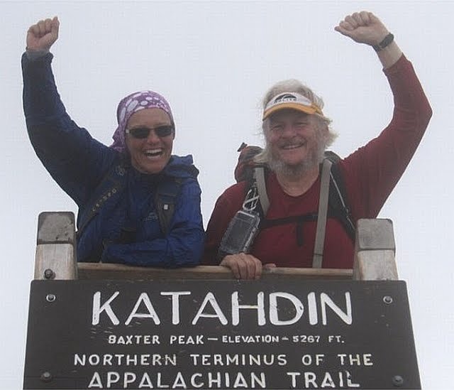
But the big news of the day is that we have less than 200 miles left to Mount Katahdin!  The plaque (see picture) marks the original northern terminus of the AT.  It was extended to Katahdin and the plaque is now at mile 199.8.  As of tonight, we have about 195 miles to go.

28 July - Spaulding Mountain Lean-to

Warmer and more humid, high in low 80s.

Short hike today but still tough.  We finished before 3:00 so we will get a good rest tonight.  The four of us are still hiking together (Flatlander, Capt. Bly, and us). 

Also in the lean-to (shelter) are Seminole and Turtleback.  Seminole is new to us.  She hiked the same trail today that we hiked the last two days.  She is from Virginia.  Turtleback has been around for about a week - sometimes hiking with us or in the shelter, sometimes not.  He is finishing a thru-hike he started in 2008.  He hikes at a similar pace so we may see more of him.

Forecast is for rain tonight. 

Pictures from July 28

27 July - Poplar Ridge Shelter

Mostly sunny and cool, high 60s, low 70s. Gorgeous day for hiking.

Before I forget, I should mention that the trail has generally been well maintained and well blazed since leaving southern Maine (where AMC still has control) and entering trail maintained by the Maine Appalachian Trail Club. We even had switchbacks again today.

We hiked over Saddleback Mountain today. The name is interesting because Saddleback is the name of the first mountain north of Swift Run Gap crossing the AT and Skyline Drive where we live in Virginia. The weather was clear and we could actually see Mount Washington on the horizon. Supposedly you can also see Mount Katahdin but we could not pick it out.

We had a 2300 foot climb to start and several more 500 foot climbs. There was almost three miles above tree line. It was beautiful. We don't have many opportunities above tree line left. I took lots of pictures.

Pictures from July 27 (Saddleback Mountain)

Goodbye Rangeley

Tuesday, July 27, 2010

26 July - Rt. 4, east of Rangeley

Very breezy, high in upper 60.

Wendy and Flatlander did not get back until 1:30 am.  Slept late,  did a resupply,  and went to post office.  Did not start hiking until 10:00. 

Hiked 13.3 miles today.  But it was the best trail in three weeks.  Still lots of rocks,  roots, and mud.   Wendy slipped into the mud (see picture ).  But not a lot of climbs.   Hiked faster - done by 6:00 - which is good because we did not start until 10:00. 

There are lots of lakes in Maine.  Everyone is feeling good except me. I was slow today due to pain in hips and legs. 

Rangeley has been nice but back to camping tomorrow.

Sunday, July 25, 2010

25 July - Rangeley, zero day

Heavy rain overnight but only a little here so far.  High mid 70s.

Tried to stay at Gull Pond Hostel but it was full (and not too appealing ).  We (Capt. Bly and I) are at the Rangeley Inn.  Wendy went with Plans Too Much to keep Flatlander company on the way back here.  Looks like a six plus hour trip each way. 

Capt. Bly and I get to rest after check in and resupply for tomorrow.

Pictures from 24 June, Sat.

24 July - South Arm Road to Rt. 17

Foggy, misty, cool, and light rain most of the day.  Sun briefly came out late afternoon and it was warm and humid. High low 80s.

As you see from the weather, it was a mushroom day.

We hiked 13.3 miles starting with a 2400 foot climb up Old Blue. Mtn.   from South Arm Rd.  and ended with a steep climb down and back up to Rt. 17.  Capt. Bly's car was parked at an overlook just up from where the AT crosses  Rt. 17.  We celebrated our success while the sun set over Mooselookmeguntic lake.

It is supposed to rain tonight and tomorrow so we are planning a zero in Rangeley and Plans Too Much will take Flatlander to get his car in Unionville, NY. 

Friday, July 23, 2010

23 July - East B Hill Rd. to South Arm Rd.

Sunny and warm, low 80s.

Nice hike today. Hiked up to Surplus Pond and over Wyman Mtn. Then hiked down to Sawyer Notch and up and over Moody Mtn., 1400 feet in less than one mile. Everyone warned us about it but it was not bad compared to what we have done in the Whites and Mahoosucs. Trail is definitely getting back to normal.

Because of all the steep climbs, I have gotten pretty good at throwing my poles (so I can use both hands to climb). At first I just threw them up or down the trail and hoping that they did not slide out of reach. Now I try to get them to stick in the ground or go into vegetation so that they are handy to grab when I am done climbing.

All day we heard there would be trail magic until 3:00 at the far side of Moody Mtn. (our end point). We got there just in time and they were still there. Birches (2009) and Snakeyes had drinks in the river and were cooking hamburgers on a gas grill. They also had fruit and vegetables. Very nice folks who drove all the way from Vermont to do trail magic on South Arm Rd. in Maine - perfect for us. Plans Too Much is also from Vermont and they may do more trail magic together in the future.

We will be staying at Pine Ellis Lodge in Andover for at least one more night. Still working out our future plans for slack packing etc. with Capt. Bly.