Last night after dinner, we said goodbye to Flatlander. He started his trip home. Tonight he should be in Unionville, NY, having a celebration dinner at the Mayor's house. (The Mayor's house is a hiker hostel owned by the former mayor of Unionville).
This morning we said goodbye to Capt. Bly. He is heading to pick up his wife today and start the long trip back to the Houston area.
We left with Esther for her house on a lake in upstate NY. We have finished dinner and I am about to work on plans to get back to VA. We need to get Andi ready for her trip to Madagascar. Then we will make a decision about hiking the rest of the trail this year.
I will post again when we have a decision.....
Wednesday, August 18, 2010
17 Aug - the hike down


The AT goes up the Hunt Trail. We chose to go down a different way -the Saddle Trail and Chimney Pond Trail to Roaring Springs Campground where Esther met us.
It was supposed to be easier and probably was. But it was not easy. Chimney Pond was beautiful and view of the other side of Katahdin was spectacular.
The last day ended with a final moose sighting. It was a mother and calf. This time I was close enough to get a picture, even with a phone cam.
We had a final dinner at the AT Cafe including the Summit Sundae that we all shared.
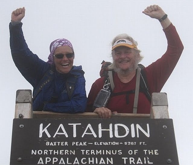
17 Aug - at the summit of Katahdin


Suddenly, out of the fog, was a small crowd of people and we were there. The summit sign. End of the trail.
We saw some folks we knew: Appy and Pappy, Pi, Poppins, and others.
It was windy and cold! We ate but were not comfortable. I had on three layers of clothes.
We stayed about 45 minutes taking pictures and talking to other hikers. We hoped it would clear but it did not.
17 Aug - Climb up Katahdin, part 2

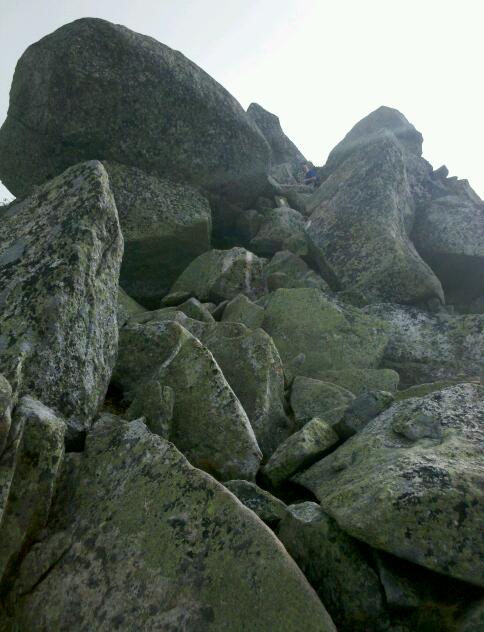


The higher we went, the colder it became. Sometimes we were on the clouds and fog but sometimes we got brief but spectacular views.
The climb became a lot more difficult until we reached the tablelands.
17 Aug - Climb up Katahdin


The weather forecast was good when we started the climb but it was still
cloudy with a little misting rain. We were hopeful.
Katahdin Falls was beautiful and the initial climb up was not too difficult.
Tuesday, August 17, 2010
17 Aug - Baxter Peak, Mt. Katahdin

We made it to the top!
We are back down and have been to dinner at the AT Cafe again. I will update the journal with more pictures tomorrow. We are traveling to New York tomorrow so not sure when.
Monday, August 16, 2010
16 Aug - Rain day

As predicted it rained so we stayed in Millinocket. Spent a lot of time at the AT Cafe. Fortunately the food is good because we were there for breakfast, lunch, and dinner.
Tomorrow the forcast is better and we plan to summit Katahdin. There seem to be a lot of people we know who have caught up to us so there will be friends climbing with us. I will send a picture when I can.
Sunday, August 15, 2010
15 Aug - The Birches (near Katahdin Stream Campground)


More great hiking weather. Mid 70s. Unfortunately the forecast is for rain tomorrow.
Immediately after leaving this morning, we crossed into Baxter State Park. We followed the Penobscot River and then the Nesowadnehunk River, a tributary. There were some beautiful rapids and waterfalls. In all, we hiked only about 10 miles and arrived at Katahdin Stream Campground before 1:00.
Instead of trying to make reservations in The Birches (special campground for up to 12 thru-hikers), we met Wendy's Aunt Esther who drove us into Millinocket for the night and will drive us back to the trail for the final climb.While waiting, we saw POW and TLC who had just returned from their climb of Katahdin. They were tired and elated. This completes their hike of the AT that they started 3 years ago. We made plans to see them later at the AT Cafe.
The Birches is next to Katahdin Stream Campground and where most thru-hikers start their climb. From there, it is only 5.2 miles along the Hunt Trail but it climbs 4150 vertical feet to the summit of Baxter Peak at 5,268 feet. It normally takes 9 hours hiking time to complete the 10.4 mile round trip.
We are going to get up at 4:30 and check the weather. Rain is likely with a chance of thunderstorms. If so, we will postpone for a day.5.2 miles to go. . . .


14 Aug - Abol Bridge Campground
Our gorgeous weather continues; high in low 70s.
Hiked 15 miles today starting along some beautiful lakes (the first one had a cooperative beaver). We had three views of Katahdin today. The first was across Rainbow Lake. The second from Rainbow Ledges, and the third was from Abol Bridge (with all four of us - taken by a helpful MATC Ridge Runner).
When we arrived at the Abol Bridge Rd., we were out of the 100 mile wilderness. We stayed at a campground. It was wonderful (soda, burgers, ice cream, showers) and terrible (many people, loud). Those people came there to be in the wilderness; we came there for civilization.
Since 02 April, Wendy and I have hiked 1150 miles on the AT. Tomorrow we will enter Baxter State Perk and hike about 10 miles to the last road crossing (near Katahdin Springs Campground).
15 miles left to go. . . .
13 Aug - Rainbow Stream Lean-to


Another glorious hiking day. Low 70s.
Ponds, lakes, streams, small waterfalls, and a gorge - all in today's hike. We hiked 16 miles today, starting with a climb up a small mountain for a view of Katahdin. When I took the picture, I was 16 miles away from Katahdin. To get there on the AT, we will have to hike 36 miles.
The lakes are beautiful and some have sand beaches. We lost Poppins on one as he went for a swim and found some fresh water mussels that he was going to cook for lunch.
This might be our last night in a shelter. This one has the old style "baseball bat floor" made of round logs laid side by side. Not very comfortable sleeping.
30 miles left to go. . . .
Subscribe to:
Posts (Atom)