Katahdin

Katahdin
Aug 17 2010 - End of Part 1

Thursday, September 30, 2010

Thur 30 Sep - Davenport Gap

Rain!  Very heavy last night and lasting all day today.  It warmed overnight (tropical air) but has cooled again.  High upper 50s.

Hiked 15.8 miles to Davenport Gap.  Finished the Smokies.  Only took one break today, in a shelter because of the rain.  Shared it with a maintenance crew - it was drier than their camp.

Driving to Hot Springs tonight.  Will get an early shuttle and hike 20+ miles back to town.

Wed 29 Sep - Tricorner Knob Shelter

Cool and cloudy this morning,h blue sky early afternoon warming to about 60.  Then cloudy, cooler, and fog, followed by rain.  Cold and wet when we got to the shelter.  The forecast had been seven days sunny but Greg sent an email with news of the tropical depression.  Within an hour, the forecast here had rain tonight aftrer midnight and in the morning.  Guess it got here early. 

We left Gatlinburg and the Grand Prix Motel this morning.  Harry runs a good place for hikers.  Recommended.   Gatlinburg/Pigeon Forge is an incredible tourist trap.  Interesting to see though.

Hiking north from Newfound Gap to Davenport Gap - 15+ miles today and 16 tomorrow.   The Smokies are very nice - like the Shenandoahs but with the altitudes of the Whites.   The vegetation is different at the higher altitudes, not alpine but more like some mountains out west.  It is a bit too regulated - no camping, reservations required at shelters - but the are not charging fees and they make exceptions for thru-hikers.  I like it here.

Passed quite a fee hikers going south this afternoon.  The shelter south will have lots of people in it tonight.  Met a couple who sounded Dutch who started their hike in Virginia.  Also met Tenderfoot who is doing a second  hike of the AT.  When she gets to Springer, she will only have Maine left.

We are sharing the shelter with Sam and his daughter Sunny.  They are pit for four days hiking the Smokies.  Samoa a traveling nurse who takes temporary jobs in various interesting places.  Currently working to get an assignment in the Virgin Islands.

Saw a half dozen wild turkeys this morning and one grouse.

It is raining hard now.  We are up on the top level, about three feet away from the metal roof.  It is getting cold but I am in my sleeping bag.  It is sure nice to be dry and warm.  Hope it improves by morning.

Tuesday, September 28, 2010

Andi's update from Madagascar

Below is the text from a message Andi sent us today reporting on here first experiences in Madasgascar.
--------------------------------------------------------------------------------------------------------

Salama!

Whew; Two weeks in the Jungle, I hardly know where to begin. I guess I should start by saying that overall I really enjoyed the experience. Everything was so different it made the tiniest thing an adventure, not to say that there weren’t plenty of huge adventures to be had. Upwards of 95% of the plant and animal species in Madagascar and endemic to the island, meaning they exist only here and nowhere else in the world. Even the species of bamboo are different than what I’m accustomed to.

We started the trip with a boat ride. We made one stop in a rural town so that our local guide could introduce us to the town “president” because Zach will be interacting with him later in the project.

The whole town smelled beautiful. Every house had huge mats of vanilla beans and cloves spread out in the sun to dry. Being as attune to smells as I am, I was in heaven there. Our next stop was an even more remote village in which we spent the night. Again we met with the village president and he helped us arrange for locals from his village to act as our porters. This seems to be a common practice for them seeing how virtually ever male showed up the next morning hoping to be hired. In the end it took twenty five of them to haul all of our equipment up to the research site.

The climb to the sight was unbelievably difficult. It was the most extreme vertical hike Zach or myself had ever experienced. There were quite a few places where you had to pull yourself up a muddy bank by tree roots. By the end my legs were killing me and I had had to stop a few times to catch my breath. When we got to the sight it had started to pour rain. The assistants we had brought with us were incredibly efficient in setting up camp. Tarps were hung, a “kitchen” was constructed, and a picnic table was fashioned in a matter of hours. It was quite a spectacle to observe. The Malagasy are incredibly resourceful people.

Every day we went out hiking through the jungle to set up camera sights. Sometimes we followed reasonably well maintained trails or more commonly we utilized game trails. However, there were plenty of hours spent hacking through the dense understory attempting to make new trails. We only got lost a few times, and it was never on my account. There were several very long days where we didn’t return to camp until after dark. The jungle becomes incredibly loud at night with the sounds of birds, insects, and frogs. It also has amazing smells. Every area you walk through has a unique sent based on the plant species.

For breakfast, lunch, and dinner, we had beans and rice. I calculated I ate the same meal roughly 40 times in a row; however, I was always so hungry I would eat two whole bowls of it easily.

Last night was our first night back here at the house. Zach’s wife attempted to make us a carrot pizza. Zach and I devoured it like it was the finest feast ever made. She also made a banana cake; the entirety of which we consumed in under an hour.

I’m starting to look forward to the idea of going home, but I’m trying to enjoy every minute of this environment while I’m here. The Malagasy culture is great. The people have so little and yet are always happy and courteous. I am treated like a princess. I’m not allowed to carry my own bags and it’s expected that I get the front seat of any boat or car we travel in. In villages we traveled to they have only seen a handful of white people in their lives and perhaps never a woman. Everywhere I go I am blatantly stared at. I often times feel like a carnival exhibit. I almost immediately collect a swarm of small children that follow me around everywhere and try to get a close as possible to me. They think my hair is the coolest thing and some will get brave enough to try to touch it, but when I turn to look at them they run away giggling.

We are trying to make homemade peanut butter now. The last attempt didn’t work out too well, but it seems delicious compared to many of the other options. Oops, we just lost power. Apparently it has happened several times, but I’ve been in the forest. I guess I should go now. I’ll write more later.

Love you all,

Andi

Tue 28 Sep - Davenport Gap to Max Patch

Yesterday it rained hard so we just rested and went to a movie. We did get a message from Andi that she was safely back from her 14 day trip into the jungle. We spoke with her yesterday and got an email from her today.

Her trip is more of an adventure than ours right now so I plan to copy her email into this journal for those of you who may be interested. It will follow this message.

Today we had "Harry" from the Grand Prix Motel arrange a shuttle for us so we could go out for a one day. Weather turned out good of course.

We hiked from Davenport Gap to Max Patch Rd. We crossed Snowbird Mountain which is a bald. That is where the pictures were taken. The radar station belongs to the FAA.

Tomorrow we go back and complete the Smokies - should take 2 days (32 miles). Then we will head north with the car to Hot Springs NC and continue hiking around there.


Sunday, September 26, 2010

Sun 26 Sep - zero day in Gatlinburg

Rain on and off all day. High mid 60s (down here).

We stayed in Gatlinburg and will again tomorrow when even more rain is forecast. I plan to go out Tuesday even though there is still rain in the forecast. We don't want to lose too much time. Weather is dry after Wednesday.

It is nice to rest and eat too much.

Saturday, September 25, 2010

Sat 25 Sep - Newfound Gap, Gatlinburg TN

Cool and foggy. High only in the low 60s in the mountains.

We hiked in the Smokies again, 8 miles from Clingmans Dome to Rt. 441 at Newfound Gap. On the way up to Clingmans Dome, we saw at least a dozen wild turkeys feeding.

The weather was very foggy and cool. We hiked in light rain for a while and then it rained hard. We tried to wait it out but it did not stop. When we arrived at the Rt. 441 road crossing, we decided to stop for the day. We were wet and it was getting cooler fast. We needed to hitch a ride back to our car at the end of Clingmans Dome road. Not surprisingly, people did not want to pick up wet hikers with packs. Wendy found a group of day hikers who agreed. Turns out the boy was a thru-hiker last year and he was with his mom and a friend. I got the car and went back for Wendy and our packs. We went into Gatlinburg, the closest town, and are staying in a hiker friendly place called the Grand Prix Motel.

Our original plan was to go a few more miles and stay in a shelter. I think we can still complete the Smokies in another two days starting at Rt. 441. However, the weather is for much more rain for the next 2-3 days. We do not want to get wet while camping especially with the temps expected to fall. We have done it earlier in the hike and had enough. We will get up in the morning and decide what to do.


Fri 24 Sep - Fontana (Hike Inn)

Still warm, mid 80s but a nice breeze made it better for hiking.

We hiked 16.4 miles again today to get back to Fontana Dam. This completes the southern part of the Smokies. Lee hiked with us all day (helps the time pass quicker having someone else to talk to). We were able to arrange his son coming to pick him up. This morning we saw a crew rebuilding a shelter.

Saw a black bear on todays hike. Had a good long view across a ravine.

We got back to the dam and walked across to complete the section on trail we did southbound. We were supposed to call the Hike Inn for a ride but we had already lost the signal coming down the mountain too far. Fortunately Nancy came by to check on us and found us on the far side of the dam.


Thur 23 Sep - Spence Field Shelter

Warm and humid still, mid 80s.

We left Hikers Inn with Jeff this morning at 6:00 and drove an hour and a half to Clingmans Dome, the highest point on the AT at 6643 feet.

We hiked 16.4 miles to get to the shelter tonight. The vegetation is definitely different due to the high altitude - not alpine like in New England due to the warmer southern climate, but different. There are more pines and lots of evidence of the dying hemlocks. Great Smokey Mountain National Park is the most visited park in the country - 10 million visitors per year. And it is free.

A good wildlife day. We saw four wild turkeys on the hike. And on the drive into the park this morning, we saw three elk. Two had very impressive racks. These elk came from the reintroduction program done in the north of the park.

We are here tonight with four other hikers. We met Lee at the second of four shelters we passed today and hiked with him the second half of today. He is waiting for a visa to leave for Saudi Arabia to teach in an English language school. He was in Korea for the previous year. He is changing his plan to hike out with us tomorrow at Fontana Dam.

John and Mike are from Michigan and this is there first hike in big mountains. Met them a couple of nights ago at the Hike Inn. We went out that night and talked hiking and they bought us dinner.

We also met Bob at the Hike Inn. He is heading north and will be on a similar schedule as us in second half of the Smokies.

Wednesday, September 22, 2010

Wed 22 Sep - Fontana Dam

Warm and humid again.  Mid 80s.  Thunder this afternoon while we were hiking but no rain on us.

We hiked from Stecoah Gap to Fontana Dam, 15.6 miles.  No new problems so we plan to enter the Smokies tomorrow.  We saw a couple of grouse, both yesterday and today.

Fontana Dam creates Fontana Lake from the Nantahala River.  The dam is the highest east of the Mississippi.  

We also passed the shelter known as the Fontana Hilton.  It can sleep 24 people and has access to bathrooms with real toilets and a shower.

I have a signal tonight because we are at the Stecoah Diner.  The special tonight is chicken fried steak.

Tue 21 Sep - Stecoah Gap

Foggy and cool at dawn becoming hot and humid.  High 88.

We hiked 13.6 miles from Stecoah Gap back south over Cheoah Bald to the Nantahala Outdoor Center (NOC).  My blisters and toenails did OK and so did Wendy's knee.  So tomorrow we resume north from Stecoah Gap to Fontana Dam.

Acorns are raining down from the oaks and in some places leaving a collection of little brown ball bearings on the trail.

We saw a snake on the trail.  Wendy passed it first and took some pictures.  She thought it might be dead.  But she walked around it and kept hiking.   I took some pictures too and confirmed it was alive - it hardly moved or responded.   I think it was a timber  rattlesnake but it was yellowish - maybe because it had just shed it's skin.

Tuesday, September 21, 2010

Mon 20 Sep - The Hike Inn, zero day

Hot, humid, low 90s.

Another round of aqua therapy this morning,  then some resupply in town and at NOC.  We drove north to the Hike Inn near Fontana Dam, our base for the next few days.

There are 30 miles left in the North Carolina section between NOC and Fontana Dam.  We will do that the next two days slack packing (with the help of Jeff and Nancy at the Hike Inn).  This will be a good, safe test for my foot.  If all goes well, we will continue into the Smokies after that.

We do not have a signal here so I am not sure when I will be able to send updates.

Sunday, September 19, 2010

Sun 19 Sep - Dicks Creek Gap, Hiawassee

Warmer and more humid.  High 88.

We made it!  68 miles in 4 days.  Back to Hiawassee.  Exhausted. Sore.  Injured.  After showers, we took the elevator down one floor, and drove across the street to the AYCE buffet.  Then hot and cold aqua therapy.  Now bed.  Recovery is proceeding well.

The two pictures (not my foot) are at Bly Gap on the Georgia - North Carolina border.  This is where Captain Blythe was given his trail name, probably eight years ago.

More tomorrow - a zero day and car relocation.

Sat 18 Sep - Standing Indian Shelter

Nice hiking weather - low 70s at the warmest.  Low humidity but still hazy. 

Today we saw two deer, a rabbit, a snake, and of course squirrels, chipmunks, mice, and even a vole.

During the night last night, I woke up could not sleep because of pain in my legs due to exertion and pain from the blisters.  I thought there was no way I could do another 20 mile day.  But after some more sleep, treating the blisters, and packing up, I felt much better.  Although I expect the same tonight.

We hiked 19.7 miles on the AT today.  After 16.7 more tomorrow, we will be back in Hiawassee (we cross back into Georgia tomorrow).

We are at Standing Indian Shelter, just below the almost 5500 foot  summit of Standing Indian Mountain (our big climb today).

North Carolina has been good hiking.  The trails are well graded - not too steep and use switchbacks.  Lot of rhododendron and mountain laurel.  We are really in the green tunnel much of the time.  It would be beautiful in spring.

Fri 17 Sep - Rock Gap Shelter

Foggy at dawn but a cooler, less humid day.  Maybe 80 in the sun but 70s in the green tunnel.

Tough day - 19.6 miles - Wendy with her knee problem and me with my blisters.  Her knee is bad on the mornings but seems to get better through the day.  Exhausting for both of us.

If we can do 19.7 tomorrow and 16.7 on Sunday, we will be back to Hiawassee and have done in four days (67.5 miles) what took us five coming north.  If we can do it without hurting ourselves.  In any case we are doing much better. 

High point today was Wayah Bald at 5342 ft. which as the stone tower being reconstructed.  Views have not been good and it is hazy. 

Some good water sources today but some dry ones too.  We need to stay fully loaded when we have the chance.   Time consuming and heavy!

Thur 16 Sep - Cold Spring Shelter

In spite of a seven day forecast for sunny weather, we had light rain in the afternoon. Enough that got out the rain gear but not enough to get us too wet. Otherwise, warm, low 80s.

This morning we drove to Sally and Joyce's house and left the car. Joyce took us north into North Carolina and the Nantahala National Forest. This area has high mountains with 4000 foot gaps and 5000+ foot peaks. Nantahala is Cherokee for "land of the noon day sun".

We climbed all morning to get from 1700 feet at the Nantahala Outdoor Center in Wesser, NC up to Wesser Bald, Rocky Bald, and Copper Ridge Bald - the last two at over 5000 feet. They must have been named long ago because they are all covered with trees and have minimal views.

The shelter we are in tonight is at 4920 feet. It was built in 1933 by the CCC. It is not well maintained - bear cables are broken for example. We would have gone to the next shelter but Wendy was not doing well. Her right knee is still a problem and she got a bee sting below the left knee. She wanted to go further but decided against it so we had a short day as I planned. Tomorrow will determine if we are out for four or five days this trip.

Water is still short supply. No rain in the forecast.

Tuesday, September 14, 2010

Wed 15 Sep - zero day in Hiawassee

Warm and humid but we have air conditioning, a pool and a hot tub so who cares. We are soaking ourselves in alternating hot and cold to relieve the aches and pains. Knees, hips, and blisters are all improving. We have been to the "all you can eat" buffet at Daniels Steak House twice.

We also have done a resupply from items in our car and from the Rite Aide down the road. Having a car is still strange but I have tentative plans for shuttles that will get us through GA, lower NC, and the Smokies.

Tomorrow, we will leave our car at Sally Smith's house again and she will take us to Nantahala Outdoor Center (Wesser NC) and we will hike south 68 miles over five days to get back to Hiawassee and our car. We will then try to repeat this cycle with a couple who live just south of the Smokies.

Becky had asked what our plans were and how many miles we have left. Here is an explanation.

We left in April with three possible goals:

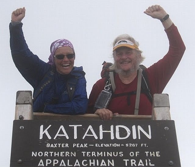
1) Hike to Mt. Katahdin in Maine
2) Complete the AT
3) Thru-hike the AT in 2010

We have decided that we do not have the time or desire to repeat this year the 300 miles we already hiked in 2007 and 2008 from Harper's Ferry to the Daleville/Troutville area of Virginia (near Roanoke). So goal 3 is out.

We decided that we do want to complete the AT this year so we have started hiking the remaining miles from the southern terminus at Springer Mountain in Georgia back up to Daleville/Troutville. This is 719 miles and it will complete the AT for us (if you include the miles hiked in previous years).

Wendy starts a job the beginning of November so we only have 6 weeks remaining. We probably will not be able to complete all of the 719 miles by end of Oct. but we will do as many as we can. There are 460 miles from Springer Mountain to the Virginia state line (includes GA, NC, Smokies, TN). It will be another 260 miles in Virginia to get back to Daleville/Troutville . Even if we go slow, this will put us well into Virginia and we will then finish the remaining miles on long weekends (she only works a 3 day week and I still do not have a job).

Phone signals have been weak and sporadic so I have not been able to update regularly. I will still try to write each day and send when I can.

My impression of Georgia is still good but I have never seen so much poison ivy. The trails have been good and the shelters have too.

Also an update on our daughter Andi and her trip to Madagascar: we have spoken to her usingSkype on the cell phones (we call the graduate researcher's local cell phone). Her trip was difficult but she likes where she is staying. On Monday she and the researcher plus 3 locals and a local Wildlife Conservation Society employee left via boat to ride up a river to a village where they start a 13 trip on foot into the forest to install cameras. In the village, they will pick 21 local guides to act as porters to carry their equipment. She seems happy.

I have a couple of links that I should have passed on sooner.

This is a nice map of the AT. As you zoom in it shows more shelters. Should give a good view of the terrain and where we are sleeping when in a shelter.

Also here is an online (PDF) version of the Thru-hikers Companion. This is the book I use on the trail to plan our hikes, stops, breaks, etc.

I will put both links on the links page.

Tue 14 Sep - Dicks Creek Gap (US 76 Hiawassee)

Warmer and more humid today, highs in the mid to upper 80s.

We hiked 11 miles to Dicks Creek Gap where Sally Smith picked us up in her VW camper and took us to our car at her house. We drove to Hiawassee and are staying at the Holiday Inn again. The next 36 hours are for rest.

Wendy's knee problems continue to be bad but today they improved after about an hour and did not return. However, we both are very sore in general. I am having knee and hip problems continue but right now, the worst problem is blisters on my left foot.

We are taking a zero day tomorrow. There have been some questions asked that I will post answers tomorrow and describe what we are doing....


Mon 13 Sep - Tray Mountain Shelter

A cold night last night after the storms went through. I did not have enough clothes. But warmer today and more humidity. Highs in low 80s.

We hiked 15 miles again today. When we stopped for lunch at a shelter, we saw that Muncher signed the register so he did continue hiking and spent the night there. So he is ahead of us and we should see him again.

I feel that I am immediately back into the rhythm of hiking on the trail. I was worried that it would be difficult to go back after such a long rest. It is clear that we have lost our hiking legs but I feel the strength returning. We have done good miles and much more that when we started in April. I think we can do even more. I like the trail here and the shelters have all been very nice.

We had a three mile climb at the end of the day that was hard going. When we arrived at Tray Mountain shelter, we met Flipper (thru-hiked in '96) who offered Wendy some coffee. He brought it to us and we talked for a while. He is out for over 3 weeks and just taking his time going from shelter to shelter and "enjoying the trail". He plans another thru-hike at some time in the future. He had killed a rattlesnake and eaten it - he showed us the skin. In addition, there were two snake skins in the shelter courtesy of Flipper. He said it keeps the mice away.


Sun. 12 Sep - Low Gap Shelter


It rained last night so it was nice to be indoors! Cooler and less humid after the storms. Good hiking, highs in upper 70s.

The pictures above were taken this morning before we left Neels Gap. The pictures show Mountain Crossings at Walasi-Yi, an outfitter, hostel, info center and tourist trap located in Neels Gap. The Appalachian Trail run right through the building (only place on the trail). It is a nice place for hikers and has been for years. The current owner, bought it 10+ years ago and wrote a book about it. It has some good stories about the happenings there although we learned that we should not believe everything in the book and that much has changed since the book was published.

However, we did stay in the hostel and had a wonderful time. We were dead tired on arrival and learned (from Muncher) that 11 women who were supposed to be there did not stay and that there was a lot of food available. We had great Sloppy Joe's courtesy of Pirate. He has been running the hostel for many years and was one of the characters in the book. There was also a breakfast in the morning. We left a generous donation to cover costs.

We did a resupply of our food in the morning from the outfitters when it opened and then left for Low Gap Shelter. It was only a 11 mile day but we had a late start and the next shelter was another 7 miles. Also, Wendy's knee problems continue. In addition, I developed blisters because my boots did not get dried last night (as did Wendy's and Muncher's). Wet socks = blisters. I spite of the set backs, we made it before dark and had a good dinner.

Muncher is a section hiker who is also going north. He has no real time table. He left before we did and he was not at the shelter so not sure if we will see him again.